

According to the latest research by Growth Market Reports, the global Geo-Spatial Agriculture Analytics market reached USD 1.94 billion in 2024 and is projected to expand at a strong compound annual growth rate (CAGR) of 13.2%, reaching USD 5.45 billion by 2033.
This rapid growth is being driven by the accelerating adoption of precision agriculture technologies, the expansion of IoT-enabled farming systems, and the global push toward more sustainable and resource-efficient agricultural practices.
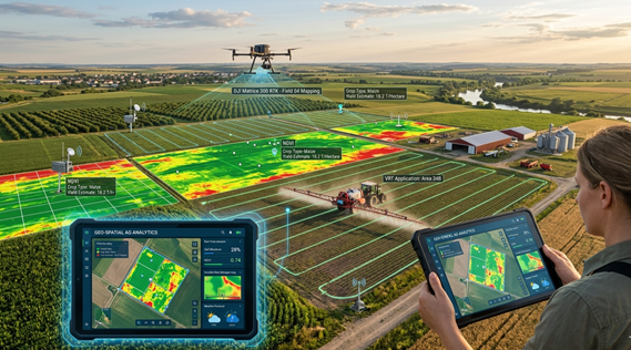
The market is becoming a foundational component of modern agriculture, enabling farmers, agribusinesses, and governments to use spatial intelligence and real-time data to improve productivity, optimize inputs, and enhance environmental sustainability.
Key Growth Drivers
Rising adoption of precision farming
A major factor fueling market expansion is the shift toward precision agriculture. Farmers are increasingly using geo-spatial analytics to optimize crop production while reducing the use of fertilizers, water, and pesticides. This targeted approach improves efficiency while minimizing environmental impact.
Integration of AI, IoT, and big data
The convergence of advanced technologies is reshaping the sector. IoT sensors collect real-time field data, while artificial intelligence and big data analytics convert this information into actionable insights. This enables smarter decision-making across planting, irrigation, and crop protection.
Government-led digital agriculture initiatives
Many governments are actively supporting agricultural modernization through subsidies, smart farming programs, and rural digitization initiatives. These efforts are significantly boosting the adoption of geo-spatial analytics platforms in both developed and emerging markets.
Market challenges
Despite strong momentum, the industry still faces notable challenges. High initial investment costs remain a barrier for many farmers, particularly in developing regions. Limited digital literacy, concerns around data privacy, and integration difficulties with legacy farming systems also continue to slow adoption.
Technological advancements shaping the market
Technological innovation is transforming geo-spatial agriculture analytics into a highly precise and predictive tool. High-resolution satellite imagery and remote sensing technologies now allow real-time monitoring of crop health, soil moisture levels, and vegetation patterns.
Artificial intelligence and machine learning are further enhancing predictive capabilities, enabling early detection of pest outbreaks, improved yield forecasting, and optimized irrigation management. These advancements are making agriculture more data-driven, efficient, and resilient.
Competitive landscape
Key players operating in the market include:
- Trimble Inc.
- Deere & Company
- Raven Industries
- Ag Leader Technology
- Bayer Crop Science (Climate LLC)
- Corteva Agriscience (Granular)
- Topcon Positioning Systems
- Taranis
- Planet Labs
- Descartes Labs
These companies are heavily investing in satellite analytics, AI-driven platforms, and precision agriculture tools to strengthen their market position.
Future outlook
The outlook for the Geo-Spatial Agriculture Analytics market remains highly positive. As global food demand continues to rise, the need for smarter, more efficient agricultural systems is becoming critical. Continued advancements in satellite imaging, machine learning, and digital farming platforms will further enhance predictive accuracy and decision-making.
Geo-spatial analytics is expected to play a central role in building more sustainable, resilient, and productive agricultural systems worldwide over the next decade.