

The agricultural industry is undergoing a revolution in precision farming, driven by technological advancements that enable farmers to enhance crop yields, improve resource management, and promote sustainability. A key catalyst in this transformation is the increasing adoption of agricultural mapping services. These services, which utilize geospatial technology and advanced mapping tools, are empowering farmers to make data-driven decisions that boost productivity while minimizing environmental impact and resource waste.
The global agricultural mapping services market is forecast to grow at a compound annual growth rate (CAGR) of 5.1%, increasing from an estimated US$6.2 billion in 2024 to US$8.7 billion by 2031. As the demand for sustainable farming practices grows, these services are playing a pivotal role in shaping the future of agriculture.
What Are Agricultural Mapping Services?
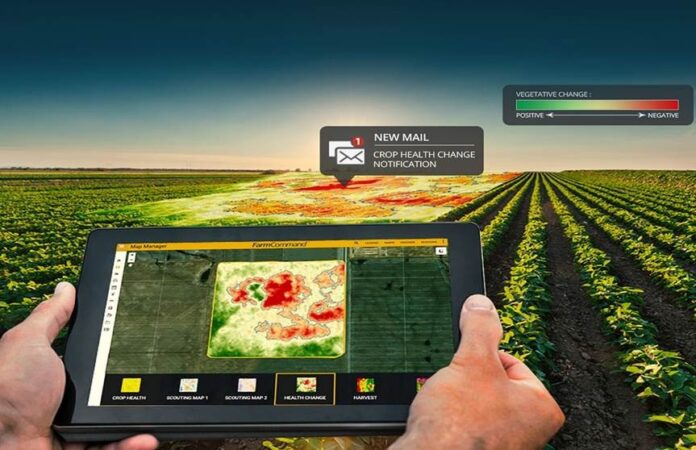
Agricultural mapping services combine satellite imagery, Geographic Information Systems (GIS), drones, and other geospatial technologies to create detailed maps of agricultural fields. These maps provide valuable insights into various aspects of farming, such as soil health, crop growth, water usage, and pest infestations. The data collected through these services is analyzed and processed to offer farmers actionable intelligence, enabling them to make informed decisions about planting, irrigation, fertilization, and crop protection.
By integrating these geospatial insights into farm management systems, agricultural mapping services give farmers a comprehensive view of their operations. This allows for precise monitoring and management of crops, leading to improved efficiency, higher yields, and reduced costs, as highlighted by Persistence Market Research. These technologies are reshaping the farming landscape, making operations more efficient, productive, and sustainable.
The Role of Precision Farming in Agricultural Mapping Services
Precision farming, which heavily relies on geospatial data, involves the use of technology to monitor and manage field variability in crops. Its goal is to optimize management practices at the field level, enhancing crop production. Agricultural mapping services play a central role in precision farming by providing real-time data on key variables impacting crop growth.
For instance, geospatial data can pinpoint areas of a field that need more or less water, fertilizers, or pesticides. This allows farmers to apply inputs precisely where needed, reducing waste and minimizing environmental impact. Furthermore, by detecting issues like nutrient deficiencies, pest outbreaks, or water stress in real-time, agricultural mapping services enable farmers to act quickly, preventing these problems from negatively affecting crop yield.
The integration of Geographic Information Systems (GIS) with agricultural mapping services has been transformative, allowing farmers to visualize and analyze data within the context of their unique farm environment.
Key Benefits of Agricultural Mapping Services
- Increased Efficiency: Agricultural mapping services provide farmers with accurate, real-time data that helps optimize resource use, leading to better yield predictions and reduced operational costs. Inputs like water, fertilizers, and pesticides are applied more efficiently, saving time and money.
- Enhanced Sustainability: With growing environmental concerns, agriculture is under pressure to adopt more sustainable practices. Mapping services help reduce waste and minimize environmental impact. For example, precise irrigation mapping helps conserve water, while nutrient mapping ensures that fertilizers are used only when and where necessary, reducing runoff and pollution.
- Improved Crop Yield: By gaining a better understanding of field conditions, farmers can make more informed decisions that lead to higher crop productivity and improved quality.
- Reduced Risk: Agricultural mapping services help farmers quickly identify weather-related risks, pest infestations, or soil erosion, allowing them to take preventive measures to reduce the likelihood of crop loss.
- Technological Advancements: The continuous development of technologies like drones, satellite imagery, and AI-driven analytics has greatly enhanced the capabilities of agricultural mapping services. Drones capture high-resolution images and real-time data for detailed crop monitoring, while Artificial Intelligence (AI) and Machine Learning (ML) enable rapid analysis of large datasets, helping farmers make smarter decisions faster.
- The Rise of Smart Farming: The global shift towards smart farming, which integrates IoT devices, sensors, and data analytics to optimize farm operations, is boosting the demand for agricultural mapping services. These services provide essential data for real-time monitoring and decision-making, making them a vital component of smart farming strategies.
- Sustainability Focus: Increasing concerns about climate change and resource depletion are driving the push for more sustainable agricultural practices. Farmers are increasingly turning to geospatial technologies to lower their environmental footprint and enhance sustainability.
- Government Support and Initiatives: Governments worldwide are supporting the adoption of precision agriculture by offering subsidies, incentives, and funding for technological advancements.
Challenges and the Future of Agricultural Mapping Services
Despite the promising growth of the agricultural mapping services market, several challenges must be addressed. One significant hurdle is the high initial investment required for geospatial technologies. Small-scale farmers may find it difficult to afford these advanced services. However, as the market matures, the cost of these technologies is expected to decrease, making them more accessible to a broader range of farmers.
Another challenge is the integration of agricultural mapping services with other farm management systems and technologies, particularly concerning data compatibility and infrastructure. Ensuring seamless integration will be crucial to maximizing the potential of these services.
Looking ahead, the agricultural mapping services market is expected to continue expanding as farmers increasingly embrace technology to boost efficiency, productivity, and sustainability.
Conclusion
The agricultural mapping services market is at the forefront of the precision farming revolution, providing farmers with powerful tools to optimize their operations and drive sustainability. With technological advancements, growing demand for sustainable practices, and increasing government support, the market is poised for significant growth, ushering in a new era of more efficient, productive, and environmentally responsible farming practices.